Updated - Cyclone Nathan to reach Cat 3 but unlikely to cross coast
Updated 5:00am: Cyclone Nathan moves further east away from coast
Original article: Tuesday March 10 2015, 3:00pm
Last updated: Sunday March 15 2015, 5:00am

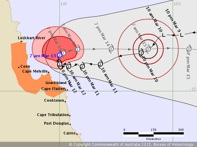
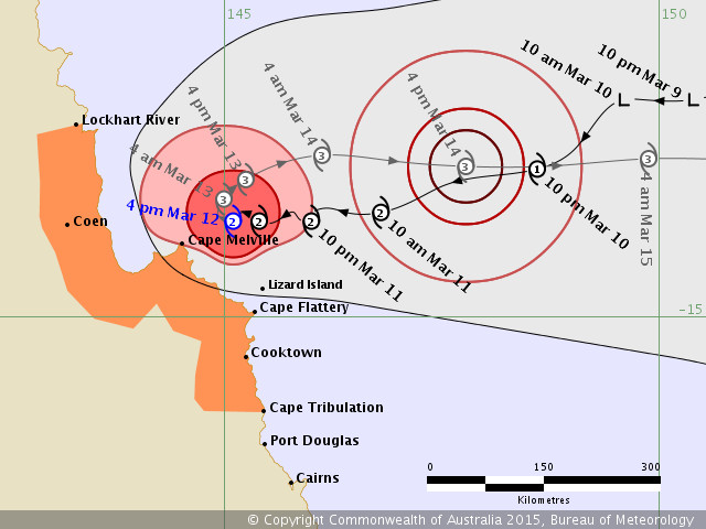
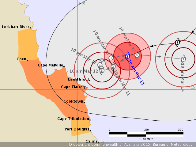
The forecast path shown above is the Bureau's best estimate of the cyclone's future movement and intensity. There is always some uncertainty associated with tropical cyclone forecasting and the grey zone indicates the range of likely tracks of the cyclone centre.
Due to the uncertainty in the future movement, the indicated winds will almost certainly extend to regions outside the rings on this map. The extent of the warning and watch zones reflects this.
This product is designed for land-based communities; mariners should read the coastal waters and high seas warnings.
Headline:
Category 1 Nathan is moving steadily eastwards, away from the Queensland coast.
Areas affected:
Warning zone: None.
Watch zone: None.
Details of Tropical Cyclone Nathan at 4:00 am EST:
Intensity: category 1, sustained winds near the centre of 75 kilometres per hour with wind gusts to 100 kilometres per hour. Location: within 55 kilometres of 13.4 degrees South, 147.5 degrees East , 335 kilometres east northeast of Cape Melville and 340 kilometres northeast of Cooktown . Movement: east at 16 kilometres per hour .
Hazards:
Tropical Cyclone Nathan has been moving steadily eastwards away from the Queensland coast over the past 12 hours, and this general motion is extected to continue for the next day or two. Following this, the system is likely to become slow-moving over the western Coral Sea. The cyclone remains a weak category 1 system at present, however it is expected to remain in a favourable environment for strengthening during the next day or two.
The system is not expected to have any significant impacts along the Queensland coast in the next three days.

UPDATED March 13, 8:00am - The following is the latest Tropical Cyclone advice issued for Cyclone Nathan by the Bureau of Meteorology:
Cyclone Nathan is drifting slowly northward. Cyclone warning cancelled south of Cape Flattery.
Areas Affected:
Warning Zone
Lockhart River to Cape Flattery.
Watch Zone
None.
Cancelled Zone
Cooktown to Cape Flattery.
Details of Tropical Cyclone Nathan at 7:00 am EST:
Intensity: Category 2, sustained winds near the centre of 100 kilometres per hour with wind gusts to 140 kilometres per hour.
Location: within 45 kilometres of 13.4 degrees South 145.0 degrees East, estimated to be 100 kilometres north northeast of Cape Melville and 230 kilometres north of Cooktown.
Movement: north northwest at 5 kilometres per hour.
Cyclone Nathan has maintained its intensity as a category 2 cyclone and is drifting slowly northward off the northeast Queensland coast north of Cape Melville. It is expected to begin moving east away from the coast today.
Hazards:
GALES currently extend out to approximately 170 kilometres from the centre to the north of the system and about 100 kilometres to the south of the system. GALES are could develop about coastal and island areas between Lockhart River and Cape Melville today, and could develop south towards Cape Flattery this afternoon depending on the track the cyclone takes.
VERY DESTRUCTIVE WINDS are expected to develop within 45 kilometres of the centre later today or tonight. It is now very unlikely that anywhere on the Queensland coast would experience these winds.
DESTRUCTIVE WINDS currently extend out to around 70 kilometres from the centre. There is now only a low proabability that coastal areas between Lockhart River and Cape Melville would experience these winds.
Areas of heavy rain will continue about parts of the Peninsula and North Tropical Coast and Tablelands districts this morning before gradually easing towards the end of today as the cyclone moves away from the coast. A Flood Watch is current for North Tropical Coast catchments north of Innisfail and some Flood Warnings are also current, refer to these products for further details.
Abnormally high tides could develop about coastal and island areas between Coen and Cape Flattery today with large waves possibly leading to minor flooding along the foreshore if the cyclone takes a more westward track closer to the coast. People living in areas that could be affected by this flooding should take measures to protect their property as much as possible and be prepared to help their neighbours in case this scenario occurs.
Recommended Action:
People between Lockhart River and Cape Flattery should immediately commence or continue preparations, especially securing boats and property.
- For cyclone preparedness and safety advice, visit Queensland's Disaster Management Services website (www.disaster.qld.gov.au)
- For emergency assistance call the State Emergency Service (SES) on 132 500 (for assistance with storm damage, rising flood water, fallen trees on buildings or roof damage).
Next Advice:
The next advice will be issued by 11:00 am EST Friday 13 March.
This warning is also available through TV and Radio Broadcasts; the Bureau's website at www.bom.gov.au or call 1300 659 212. The Bureau and the State Emergency Service would appreciate this warning being broadcast regularly.

UPDATED 4:20pm - The following is the latest Tropical Cyclone advice issued for Cyclone Nathan by the Bureau of Meteorology:
Cyclone Nathan continues to edge closer to the Queensland coast but is expected to begin slowing this evening.
Latest updates: Visit BOM http://www.bom.gov.au/products/IDQ65002.shtml
Areas Affected:
Warning Zone
Lockhart River to Port Douglas.
Watch Zone
None.
Cancelled Zone
None.
Details of Tropical Cyclone Nathan at 1:00 pm EST:
Intensity: Category 2, sustained winds near the centre of 95 kilometres per hour with wind gusts to 130 kilometres per hour.
Location: within 55 kilometres of 13.8 degrees South 145.2 degrees East, estimated to be 100 kilometres north northwest of Lizard Island and 185 kilometres north of Cooktown.
Movement: west at 6 kilometres per hour.
Cyclone Nathan is continuing to move slowly west towards the coast north of Cape Flattery. It is expected to slow this movement during today and ultimately change direction to the east-northeast away from the coast over the next 24 hours.
Hazards:
GALES extend out to approximately 110 kilometres from the centre to the north of the system and about 60 kilometres to the south of the system. GALES could develop about coastal and island areas between Coen and Port Douglas today. GALES could extend north to Lockhart River overnight and into Friday, depending on the track the cyclone takes.
VERY DESTRUCTIVE WINDS are expected to develop within 45 kilometres of the centre early Friday morning and could begin to affect coastal and island areas between Cape Flattery and Cape Melville.
DESTRUCTIVE WINDS extend out to 70 kilometres from the centre and could develop about the coast and islands between Cooktown and Cape Melville, including Lizard Island, today.
Areas of heavy rain, which may lead to flash flooding, are expected across parts of the North Tropical Coast and Tablelands and Peninsula districts throughout today. A separate Severe Weather Warning for heavy rainfall and damaging winds is current for parts of these districts.
Abnormally high tides could develop about coastal areas between Coen and Cape Tribulation during today with large waves possibly leading to minor flooding along the foreshore if the cyclone takes a more westward track closer to the coast. People living in areas that could be affected by this flooding should take measures to protect their property as much as possible and be prepared to help their neighbours in case this scenario occurs.
Recommended Action:
People between Lockhart River and Port Douglas should immediately commence or continue preparations, especially securing boats and property.
- For cyclone preparedness and safety advice, visit Queensland's Disaster Management Services website (www.disaster.qld.gov.au)
- For emergency assistance call the State Emergency Service (SES) on 132 500 (for assistance with storm damage, rising flood water, fallen trees on buildings or roof damage).
Next Advice:
The next advice will be issued by 5:00 pm EST Thursday 12 March.
----

UPDATED 11:30am - The following is the Tropical Cyclone advice issued for Cyclone Nathan by the Bureau of Meteorology:
Cyclone Nathan close to the Queensland coast north of Cape Flattery.
Areas Affected:
Warning Zone
Lockhart River to Port Douglas.
Watch Zone
None.
Cancelled Zone
None.
Details of Tropical Cyclone Nathan at 10:00 am EST:
Intensity: Category 2, sustained winds near the centre of 95 kilometres per hour with wind gusts to 130 kilometres per hour.
Location: within 45 kilometres of 13.9 degrees South 145.4 degrees East, estimated to be 85 kilometres north of Lizard Island and 175 kilometres north of Cooktown.
Movement: west at 5 kilometres per hour.
Cyclone Nathan is continuing to move slowly west towards the coast near Cape Flattery. It is expected to slow this movement during today and ultimately change direction to the east-northeast away from the coast over the next 24 hours
Hazards:
GALES extend out to approximately 100 kilometres from the centre to the south of the system and could develop about coastal and island areas between Coen and Port Douglas today. GALES could extend north to Lockhart River overnight and into Friday, depending on the track the cyclone takes.
VERY DESTRUCTIVE WINDS are expected to develop within 45 kilometres of the centre early Friday morning and could begin to affect coastal and island areas between Cape Flattery and Cape Melville.
DESTRUCTIVE WINDS extend out to 70 kilometres from the centre and could develop about the coast and islands between Cooktown and Cape Melville, including Lizard Island, today.
Areas of heavy rain, which may lead to flash flooding, are expected across parts of the North Tropical Coast and Tablelands and Peninsula districts throughout today. A separate Severe Weather Warning for heavy rainfall and damaging winds is current for parts of these districts.
Abnormally high tides could develop about coastal areas between Coen and Cape Tribulation during today with large waves possibly leading to minor flooding along the foreshore if the cyclone takes a more westward track closer to the coast. People living in areas that could be affected by this flooding should take measures to protect their property as much as possible and be prepared to help their neighbours in case this scenario occurs.
Recommended Action:
People between Lockhart River and Port Douglas should immediately commence or continue preparations, especially securing boats and property.
- For cyclone preparedness and safety advice, visit Queensland's Disaster Management Services website (www.disaster.qld.gov.au)
- For emergency assistance call the State Emergency Service (SES) on 132 500 (for assistance with storm damage, rising flood water, fallen trees on buildings or roof damage).
Next Advice:
The next advice will be issued by 2:00 pm EST Thursday 12 March.
------------
UPDATED 7:00am - The following is the latest update on Cyclone Nathan from the Bureau of Meteorology:
TOP PRIORITY FOR IMMEDIATE BROADCAST
TROPICAL CYCLONE ADVICE NUMBER 12
Issued at 5:05 am EST on Thursday 12 March 2015
Headline:
Cyclone Nathan category 2, moving slowly southwest towards the coast.
Areas Affected:
Coen to Port Douglas.
Lockhart River to Coen.
Details of Tropical Cyclone Nathan at 4:00 am EST:
Intensity: Category 2, sustained winds near the centre of 95 kilometres per hour with wind gusts to 130 kilometres per hour.
Location: within 45 kilometres of 13.8 degrees South 145.8 degrees East, estimated to be 105 kilometres north northeast of Lizard Island and 195 kilometres north northeast of Cooktown.
Movement: west southwest at 5 kilometres per hour.Cyclone Nathan is continuing to move slowly southwest towards the coast near Cape Flattery. It is expected to slow this movement during today and ultimately change direction to the east-northeast away from the coast over the next 24 hours.
Hazards:
GALES extend out to approximately 160 kilometres from the centre and could develop about coastal and island areas between Coen and Port Douglas today. GALES could extend north to Lockhart River during Friday, depending on the track the cyclone takes.
VERY DESTRUCTIVE WINDS are expected to develop within 45 kilometres of the centre overnight tonight and could begin to affect coastal and island areas between Cape Flattery and Cape Melville.
DESTRUCTIVE WINDS extend out to 70 kilometres from the centre and could develop about the coast and islands between Cooktown and Cape Melville, including Lizard Island, today.
Areas of heavy rain, which may lead to flash flooding, are expected across parts of the North Tropical Coast and Tablelands and Peninsula districts throughout today. A separate Severe Weather Warning for heavy rainfall and damaging winds is current for parts of these districts.
Abnormally high tides could develop about coastal areas between Coen and Cape Tribulation during today with large waves possibly leading to minor flooding along the foreshore if the cyclone takes a more westward track closer to the coast. People living in areas that could be affected by this flooding should take measures to protect their property as much as possible and be prepared to help their neighbours in case this scenario occurs.
Recommended Action:
People between Coen and Port Douglas should immediately commence or continue preparations, especially securing boats and property.
- For cyclone preparedness and safety advice, visit Queensland's Disaster Management Services website (www.disaster.qld.gov.au)
- For emergency assistance call the Queensland Fire and Emergency Service (QFES) on 132 500 (for assistance with storm damage, rising flood water, fallen trees on buildings or roof damage).
People between Lockhart River and Coen should consider what action they will need to take if the cyclone threat increases.
- Information is available from your local government
- For cyclone preparedness and safety advice, visit Queensland's Disaster Management Services website (www.disaster.qld.gov.au)
- For emergency assistance call the Queensland Fire and Emergency Service (QFES) on 132 500 (for assistance
IDQ20023
Australian Government Bureau of Meteorology?Queensland?Tropical Cyclone Warning Centre
Media: The Standard Emergency Warning Signal should NOT be used with this warning.
with storm damage, rising flood water, fallen trees on buildings or roof damage).
Next Advice:
The next advice will be issued by 8:00 am EST Thursday 12 March.
UPDATED 12:00 March 11- Tropical Cyclone Nathan is expected to grow into a Category 3 cyclone but is the Bureau of Meteorology (BOM) predicts that it will not cross the Queensland coast.
Residents between Coen and Cape Tribulation are warned to prepare for heavy storm conditions, however, with the cyclone expected to get reach about 100 to 150 kilometres off Cape Flattery on Thursday before turning back into the Coral Sea.
Even if it does not reach the coast the cyclone will still bring heavy rains and buffeting winds to coastal communities, with residents advised to immediately begin preparing their properties for potential flash flood conditions.
Flood watch warnings have been issued for the Daintree and Mossman Rivers, and high tides could combine with large waves and storm surges to cause coastal flooding in Cape Tribulation and nearby.
Douglas Shire Council is also also providing free Disaster Resilience USB wallet cards leaded with storm surge maps and other useful information from Council's Mossman office or the Gazette office in the Saltwater Building in Port Douglas.
A poll of Newsport readers has found that just over 55 per cent believe that the cyclone will cross north of Port Douglas, while that 31 per cent believe that Nathan will not reach the coast as a cyclone.
-------
The Bureau of Meteorology (BOM) is keeping a close eye on what could be the beginnings of a tropical cyclone forming off the Queensland coast.
A monsoon trough about 700 kilometres east of Cape York has about a 50 per cent chance of forming into a tropical cyclone, BOM says.
If the trough does form into a cyclone, it will most likely track west into Cape York, away from population centres.
BOM that the cyclone could develop and move to the coast within the next few days, even as soon as Thursday, but warns that it is nigh-impossible to predict exactly where it will go or how powerful it will be.
Cleanup is continuing in Rockhampton, Yeppoon and other areas after the impact of Cyclone Marica, which damaged over 1000 homes and caused $33 million in insurance losses.