Cyclone Trevor to sweep across far north of Cape York
WEATHER

Flooding is expected to affect the Douglas Shire in the next few days as Cyclone Trevor threatens the North East of Cape York.
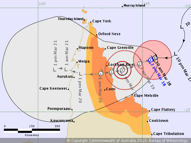
Tropical cyclone Trevor is expected to move in a west-southwest direction towards the Cape York Peninsula coast, crossing the eastern coast late Tuesday at cyclone intensity level three.
Related Coverage:
- HOW TO PREPARE FOR DISASTER WEATHER
- THE DAY PORT DOUGLAS LOST A BATTLE WITH THE WEATHER
- FALSE PERCEPTION OF PORT DOUGLAS WEATHER NOT HELPFUL, SAYS CHAMBER BOSS
The Daintree River and Mossman River are included in the Flood Watch area, which encompasses catchments between north of Cairns to Kowanyama.
As of 1.00pm today, cyclone Trevor was classed a category one with sustained winds near the centre of 85 kilometres per hour with wind gusts to 120 kilometres per hour.
While most of Douglas Shire is expected to escape the worst of the rains and wind, Cape Tribulation and Cooktown are on the outskirts of the cyclone’s predicted path.
Cooktown and northern parts of the Douglas Shire may experience wind gusts in excess of 90 kilometres per hour from late on Tuesday, depending on the changes in the movement of the weather system.
The forecast path is the Bureau's best estimate of the cyclone's future movement and intensity.
There is always some uncertainty associated with tropical cyclone forecasting and the grey zone indicates the range of likely tracks of the cyclone centre.
Port Douglas and Mossman are expected to have daily rainfall totals above 100mm for the rest of this week with rain easing over the coming weekend.
Abnormally high tides are expected along the far north Queensland coast with the high tide on Tuesday morning and again as the cyclone crosses the coast later on Tuesday.
People between Orford Ness and Cape Flattery, including Lockhart River and Coen, should immediately commence or continue preparations, especially securing boats and property, using available daylight hours.
People elsewhere between the Torres Strait Islands and Cape Tribulation, including Cooktown should consider what action they will need to take if the cyclone threat increases.
Remember: If it's flooded, forget it.
Keep up-to-date with the latest weather warnings from the Bureau of Meteorology website and the Douglas Dashboard.
Join the conversation
Thumb up or thumb down on the subject we've covered OR
place a comment below.
* Readers are encouraged to use their full details below to ensure comment legitimacy. Comments are the opinions of readers and do not represent the views of Newsport or its staff. Comments containing unlawful, obscene, defamatory, personal or abusive material will not be published.
