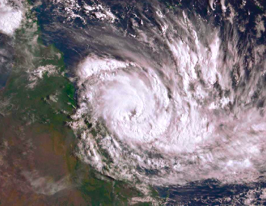
Cyclone Debbie prompts Whitsundays evacuations
UPDATE | LIVE TRACKER

UPDATE MONDAY 10.30am: The Douglas Shire is set to escape the wrath of Cyclone Debbie with the predicted category 4 system set to cross the coast near Airlie Beach on Tuesday.
The cyclone watch zone for the Port Douglas and Daintree region was cancelled over the weekend as was the stretch from Innisfail to Cardwell.
There is still a severe weather warning for the Port Douglas to Tully areas for Tuesday 'for wind and not for storm tides'.
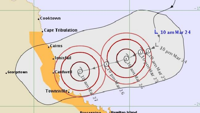
The cyclone has already reached category 2 strength and is forecast to further intensify before crossing the Queensland coast on Tuesday morning between Rollingstone and Proserpine.
Queensland Regional Director Bruce Gunn said this cyclone is very dangerous, and of a size not seen in Queensland since Severe Tropical Cyclone Yasi in 2011.
Residents in the surrounding areas have been told to evacuate.
"Communities between Lucinda and St Lawrence, including Townsville, Bowen and Mackay, may experience gales in the next 24 hours, with the Whitsundays and surrounding coastal islands among the first areas to be impacted," Gunn said.
"Storm surge is also risk factor, and if the cyclone crosses the coast around high tide this will enhance these effects. People living in coastal or low-lying areas prone to flooding should follow the advice of local emergency services and relocate while there is time."
The Bureau is also warning for abnormally high tides (large waves, storm surge and rough to phenomenal seas.
"Cyclone Debbie is likely to maintain cyclone strength for some distance inland towards Charters Towers, with damaging to destructive winds, delivering significant rainfall as it tracks to the west-southwest," Mr Gunn said.
SEVERE WEATHER UPDATE: Tropical #CycloneDebbie. Video current at 9am AEST 26/3. For latest #Cyclone info: https://t.co/v0ypxlDUrI pic.twitter.com/01fzLDyhFh
— BOM Queensland (@BOM_Qld) March 26, 2017
A ‘Category 4’ system is defined as one that has sustained winds in the range of 160-200kmh, with gusts up to 280kmh. Although the strongest winds are near the core, damaging and very destructive winds can extend several hundred kilometres from the cyclone’s centre. However, the Douglas region is set to escape the worst of it.
Based on current forecasts Townsville may be impacted by Category 3 strength winds, with gusts in excess of 165kmh.
Tropical #CycloneDebbie has strengthened overnight ...the #BOM says it could be a category four before it makes landfall pic.twitter.com/iVsieiLzZv
— ABC News 24 (@ABCNews24) March 25, 2017
Widespread daily rainfall of up to 200mm is expected with the passage of the cyclone, with isolated falls in excess of 400mm possible along the coastal fringe. A Flood Watch is current for coastal catchments between Cardwell and Gladstone extending inland to the eastern Gulf Rivers
Localised flash flooding is likely, and the public is urged to stay tuned for warnings. Avoid travel when warnings are in effect, exercise caution if caught in a heavy downpour – and never walk, ride or drive through floodwaters.

Queensland Fire and Emergency Services is urging the public to:
- Stay tuned for the latest official forecasts and warnings from the Bureau, and follow the advice of local emergency services.
- Discuss your plans for possible relocation with your loved ones so everyone knows where you are going and when you expect to be there.
- Pack an evacuation kit containing clothing, valuables, important documents, medications and sleeping gear in case you need to relocate at short notice.
LIVE CYCLONE TRACKER BELOW:
SUNDAY: The Bureau of Meteorology is now predicting Cyclone Debbie will make landfall near Townsville 'a little further south than the first advice issued.'
The low reached category one strength out at sea today and is predicted to develop as a category 4 system.
"The intensity will depend on how much time the cyclone spends over the water, with current modelling suggesting the system will intensify to severe tropical cyclone strength Category 4 [on a scale of one to five, with five being the highest]," Queensland Regional Director Bruce Gunn said.
"Storm surge is also a risk factor. If the cyclone crosses the coast on the high tide, this will enhance these effects.
Are you cyclone ready? Click here for advice
"Heavy rainfall is likely to continue well into next week for northern and central Queensland. This rainfall comes on the back of significant recent rainfall around Mackay, where catchments are already susceptible to flooding."
Although the strongest winds are near the core, damaging and destructive winds can extend several hundred kilometres from the cyclone's centre. These areas may be affected by gales as early as tomorrow (Sunday).
Communities between Cape Tribulation and St Lawrence, including Cairns, Townsville, Bowen, Proserpine, Whitsunday Islands and Mackay, are urged to prepare now for the cyclone to make landfall on Monday or Tuesday.
Click here for the Douglas Shire's Disaster Dashboard
Gunn has urged the public to stay tuned for the latest official forecasts and warnings from the Bureau, and follow the advice of local emergency services.
RESIDENTS BETWEEN CAPE TRIBULATION AND ST LAWRENCE ON HIGH ALERT
UPDATE: Douglas Shire remains in a watch zone as the developing Cyclone Debbie moved slowly towards land overnight.
Residents living between Cape Tribulation and St Lawrence are on high alert and urged to prepare for a potential category four cyclone. If it hits, it's likely to be Queensland's most damaging cyclone since the category five Marcia two years ago. Winds are predicted to get above 200km/h with the potential to severely damage homes and cut off power and phone lines.
Townsville is likely to be the most affected with the latest forecast map predicting the system to hit the area late on Monday night (10pm). However, it could cross anywhere between the watch zone as early as Sunday and authorities are urging residents to be ready.
LIVE CYCLONE TRACKER BELOW:
Queensland premier Annastacia Palaszczuk told a press conference this morning that people in Far North areas such as Port Douglas, Mossman, Daintree and Cooktown should utilise today's calm conditions to prepare for the effects of extreme weather.
Residents between Cape Tribulation and St Lawrence can expect gale force winds about the coast on Sunday, bringing with it abnormally high tides. Large waves may also develop along the beachfront.
The latest update from the bureau says the low is expected to develop into tropical Cyclone Debbie today and adopt a west-southwest track, bringing it towards the North Queensland coast.
Heavy rain is predicted into Sunday and a flood watch is current for coastal catchments between Cooktown and Mackay.
DOUGLAS SHIRE TOLD TO PREPARE FOR CYCLONE
Douglas Shire residents are being encouraged to make preparations for a possible cyclone that could develop this weekend.
Forecasters are expecting a tropical low in the Coral Sea to intensify this weekend with heavy rain and strong winds likely to affect the region.
High tides of ‘up to three metres’ are being predicted across the Shire early next week. If the low-pressure system develops into a cyclone it could cross the coast anywhere between Cooktown and Bowen as early as Sunday.
#CycloneWatch continues #CapeTribulation to #StLawrence. High chance of #Cyclone formation today. Latest info at https://t.co/YTkwbdYNGp pic.twitter.com/WfudXoDpVj
— BOM Queensland (@BOM_Qld) March 24, 2017
Douglas Shire Mayor Julia Leu said the community should start putting plans in place in the event of extreme weather.
SEVERE WEATHER UPDATE: Tropical low in the #CoralSea. Video current at 10am AEST 24/3. For latest #cyclone info: https://t.co/yS6GcA3hw4 pic.twitter.com/ehCHmDsxHG
— BOM Queensland (@BOM_Qld) March 24, 2017
“With the possibility of a cyclone forming off the coast over the weekend, now is the time to make sure you are prepared,” Leu said.
“We are encouraging people to make sure they have a plan in place. Council currently has sand and bags available at the SES shed in Mossman and the Port Douglas community hall. Sand and bags will be available at the SES Shed in Oleander Drive, Wonga from 2.30pm today.”
Bureau of Meteorology Queensland Regional Director, Bruce Gunn, said the low was located approximately 600km northeast of Cairns and Townsville, and likely reach cyclone strength 'as early as Saturday'.
Heavy rains are likely to continue well into next week for northern and central Queensland. A Flood Watch has also been issued.
"Communities between Cape Tribulation and Proserpine are urged to prepare now for a potential crossing anytime between late Sunday and early Tuesday, but the most likely scenario is for the cyclone to make landfall between Cairns and Townsville on Monday," said Gunn.
"There is always a degree of uncertainty in forecasting cyclones, for this reason we urge the public to stay tuned for the latest official warnings from the Bureau of Meteorology and follow the advice of local emergency services.
"The intensity of the cyclone will hinge on how much time the system spends over the water. If the cyclone speeds up, it is likely remain at the lower end of the spectrum, but if it crosses on Monday or Tuesday there is the potential for it to intensify to severe tropical cyclone strength, Category 3 or higher."
Our tropical #Cyclone service, check for a #Cyclone Watch likely to be issued today for the #CoralSea. https://t.co/FBmpsInT9o pic.twitter.com/upWKMz1aQy
— BOM Queensland (@BOM_Qld) March 24, 2017
Sandbags will also be made available from the Portsmith, Smithfield and Gordonvale Waste Transfer stations from 7.30am on Saturday to assist residents in low-lying or flood prone areas.
The first cyclone forecast map has been issued by the Bureau of Meteorology , showing 'Cyclone Debbie' is likely to hit the coast near Cardwell as a category three.

“It is imperative that all residents are prepared for any eventuality. Now is the time to be reviewing your Household Emergency Plan, checking your emergency kit is stocked and making any early preparations around your home," James said.
“If you live in a low-lying or flood prone area, this might mean getting sandbags ready and moving any valuable items to higher ground. If you are in a possible storm tide inundation zone, you should think about where you will go if evacuation is required. Consider staying with family or friends outside of the storm tide zones, if possible.”
The Reef Marina in Port Douglas has advised boat owners to be prepared to move their vessels up Dicksons Inlet if the extreme weather eventuates.
Tropical Low over the Coral Sea is a HIGH chance of becoming a #TropicalCyclone on Sunday. Forecasts & warnings at https://t.co/xhhEZNyxS3 pic.twitter.com/4A8JiL1ky4
— BOM Queensland (@BOM_Qld) March 23, 2017
Queensland Fire and Emergency Services Commissioner, Katarina Carroll, has urged motorists to heed warnings and avoid unnecessary travel on the roads in the event of heavy rainfall.
“We’ve already seen very wet conditions during the past week across parts of Queensland, resulting in flooding across many roads and causeways,” Carroll said.
“With additional rainfall forecast, drivers need to pay close attention to weather reports and local conditions before getting behind the wheel.”
Tropical low about 600km ENE of #Cairns. Circulation evident on Wills Island Radar. #Cyclone information at https://t.co/YTkwbdYNGp pic.twitter.com/NM4fJrevkI
— BOM Queensland (@BOM_Qld) March 23, 2017
Forecasters are closely monitoring the current weather system and will provide further advice ‘when we have a clearer indication of the likely impacts on our region’ according to James.
Douglas residents are reminded that the Port Douglas Storm Tide Cyclone Shelters will not be opened to the public unless a threat is imminent.
Information on preparing for a natural disaster, including a template for a Household Emergency Plan, emergency kit checklist, storm tide mapping and general evacuation advice can be found here.
You can keep up to speed with all the developments on Twitter with the handle @BOM_Qld and www.bom.gov.au.
Are you cyclone ready? Tell us in the comment below.
* Readers are encouraged to use their full details below to ensure comment legitimacy. Comments are the opinions of readers and do not represent the views of Newsport or its staff. Comments containing unlawful, obscene, defamatory or abusive material will not be published.
