UPDATED: Cyclone Nathan headed for Port Douglas, Cape Tribulation
Last updated Tuesday March 18 2015, 5:30pm
Originally published Monday March 16 2015, 1:45pm
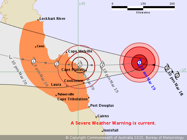
UPDATED 11am - Cyclone warnings have been cancelled south of Port Douglas as Cyclone Nathan continues to curve further north.
A Severe Weather warning is current, with the cyclone expected to land between Cape Melville and Cooktown on Friday morning as a Category 4 system.
The cyclone warning zone now extends between Port Douglas and Lockhart River.
BOM Tracking Updates: http://www.bom.gov.au/products/IDQ65002.shtml
Joint Typhoon Warning Centre: http://www.usno.navy.mil/JTWC/
-----
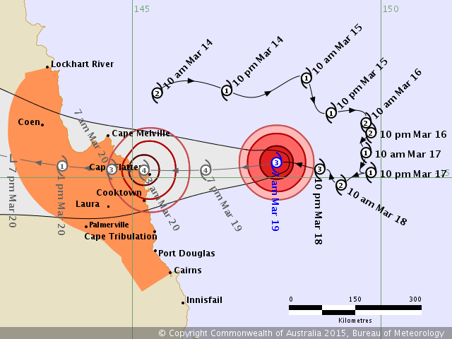
UPDATED 9:00am - Tropical Cyclone Nathan's path continues to curve slightly northward, with the latest Bureau of Meteorology predictions placing on course with Cape Flattery.
BoM's forecast for where exactly the cyclone will make landfall still remains somewhere between Cape Melville and Cape Tribulation, with Nathan expected to cross as a Category 4 on Friday morning.
The cyclone warning has been cancelled for areas south of Cairns but has been extended for a wide swath of land inland from Coen.
Cape Tribulation is now out of the strong gale force wind zone but will still likely experience heavy rainfall and possibly flash flooding.
A Yellow Alert has been issued for Port Douglas's Reef Marina.
The risk of sea flooding remains for all coastal areas of Douglas Shire as a high tide could combine with a storm surge during the cyclone's arrival.
The next cyclone update will be issued at 11am.
-----
BOM Tracking Updates: http://www.bom.gov.au/products/IDQ65002.shtml
Joint Typhoon Warning Centre: http://www.usno.navy.mil/JTWC/
-----
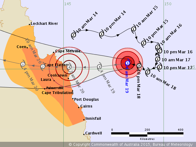
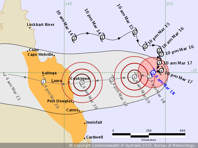
Updated 6:20am 19 March: The Bureau shows Cyclone Nathan tracking further north towards Cape Flattery this morning and expects the system to become a Categpry 4 cyclone at 4pm this afternoon.
Residents of Cooktown this morning are preparing for the worst as it appears they may be faced with the affects of the first quadrant.
The bottom right or south east of any southern hemisphere cyclone system is referred to as the first quadrant. Here storm surges and destructive winds can be the greatest as they come fresh off the coral sea.
The Bureau has release the following information:
The VERY DESTRUCTIVE CORE of severe tropical cyclone Nathan, with maximum wind gusts forecast to reach 260 km/h, is expected to make landfall between Cape Melville and Cape Tribulation early on Friday morning.
DESTRUCTIVE WINDS extend out to about 70 kilometres from the centre of the cyclone and may begin to affect coastal and island communities between Cape Melville and Cairns overnight Thursday into early Friday morning, depending on the track the cyclone takes.
Next Issue:
The next Forecast Track Map will be issued by 8:00 am EST Thursday
-----
BOM Tracking Updates: http://www.bom.gov.au/products/IDQ65002.shtml
Joint Typhoon Warning Centre: http://www.usno.navy.mil/JTWC/
-----
Cyclone Nathan to cross coast as Category 4
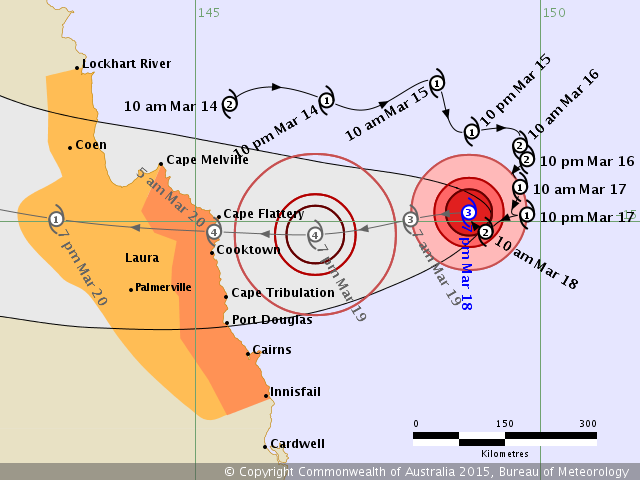
UPDATED 18 March 8:00pm - The Bureau latest tracking model is still predicting Cyclone Nathan to cross the Far North Queensland coast as a Category 4 system. Predictions now have it crossing at 5 am Friday 20 March.
Cyclone Nathan has now intensified into a Category 3 system.
Severe tropical cyclone Nathan is now beginning to adopt more of a westwards track and should continue to intensify as it approaches the north Queensland coast. At this stage, severe tropical cyclone Nathan is expected to cross the north Queensland coast between Cape Melville and Port Douglas during Friday morning.
The next cyclone update will be issued at 11:00pm tonight.
Use links below.
Newsport will resume coverage tomorrow morning.
-----
BOM Tracking Updates: http://www.bom.gov.au/products/IDQ65002.shtml
Joint Typhoon Warning Centre: http://www.usno.navy.mil/JTWC/
-----
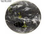
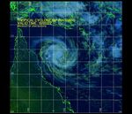
NASA satellite image from Joint Typhoon Warning Centre
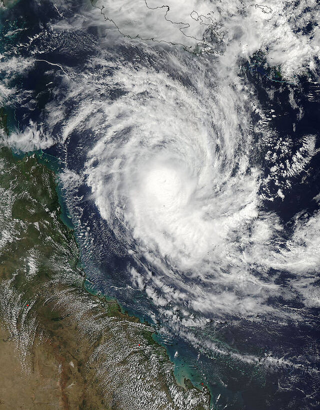
Cyclone Nathan approaches coast, headed for Cooktown
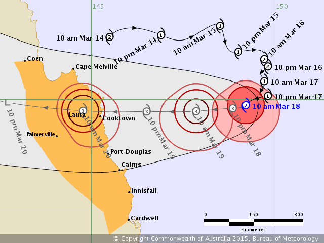
UPDATED 12:00pm - Predictions for where Cyclone Nathan will make landfall on Friday continue to move north, with the latest Bureau of Meteorology forecast now placing the cyclone just north of Cooktown.
Heavy rains will still hit a large swathe of the coast, especially areas south of the cyclone, including Mossman, Port Douglas and Cairns.
The next cyclone update will be issued at 5:00pm.
--
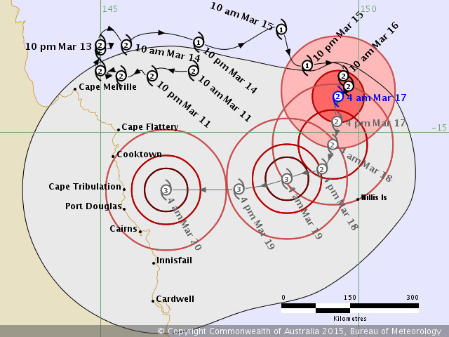
UPDATED 8:00am - The latest Bureau of Meteorology forecasts put Cyclone Nathan on a collision course with Cooktown, continuing a prediction trend of northerly movement for the system.
TC Nathan is currently a Category 1 several hundred kilometres out to sea but is expected to intensify to a Category 3 by the time it arrives at the coast on Friday morning.
Yesterday BoM had TC Nathan picked to cross the Queensland coast directly over Cape Tribulation, with earlier forecasts pegging the cyclone to hit Port Douglas dead-on.
Residents between Cape Melville and Cardwell are still urged to prepare for storm conditions, particularly to make contingencies for flash flooding.
A very high tide on Friday may coincide with storm surges and cause inundations throughout coastal areas, including Port Douglas.
Douglas Shire Council has sandbags and other equipment available and will be releasing an update from their Local Disaster Management Group (LDMG) later this morning.
-----
Tracking Updates: http://www.bom.gov.au/products/IDQ65002.shtml
-----
Cyclone Nathan to make landfall north of Cape Tribulation

UPDATED 11:30am - The Bureau of Meteorology's latest cyclone tracking map puts Tropical Cyclone Nathan as making landfall somewhere north of Cape Tribulation on Friday as a Category 3.
This represents a drift further north than this morning's prediction, where it was expected to hit somewhere on the Far North Queensland coast somewhere between Cape Tribulation and Port Douglas.
Douglas Shire Council mayor Julia Leu has urged residents to begin making preparations as Cyclone Nathan is predicted to track towards the Douglas Shire later this week.
Cairns Bureau of Meteorology forecaster Bill O'Connor said weather would suddenly turn severe on Thursday as the cyclone approached but remain calm beforehand.
"My initial thought is as it tracks closer to the coast, the leading edge will be bringing a lot of drier, warmer air, not much rainfall or wind," Mr O'Connor said.
"However on Thursday we will see the weather rapidly deteriorating - sudden change in weather, lots of wind and rain.
"It is expected to be a Category 3 which means there will be wind gusts of up to 225 kilometres per hour near the centre, and of course lots and lots of rain."
Cyclone Nathan is currently about 500km northeast of Cairns, with the Bureau of Meteorology predicting it will turn towards the Douglas Shire coastline late tomorrow and build into a Category 3 system, with a crossing tipped for Friday at this stage.
Mayor Leu said there was still plenty of time for Cyclone Nathan to change track or peter out but urged residents to start preparing now as a precaution.
“You can never be complacent with cyclones and if we are prepared for it as a community and Cyclone Nathan leaves us alone then all the better,” Mayor Leu said.
“At this stage it is expected to cross the coast as at least a Category 3 system with destructive winds, potentially in excess of 200km/h, some time on Friday.
“Unfortunately this coincides with some of our highest tides for the year on Friday and Saturday so the potential for a damaging storm surge if Cyclone Nathan does cross the coast in the Douglas Shire is significant.”
Mayor Leu said there were a number of resources available on Council’s website to help residents prepare for a cyclone.
“Simply go to the Disaster and Emergency Information on our website douglas.qld.gov.au/community/disaster-and-emergency-information/ for everything from storm surge maps, emergency kit checklists, emergency contacts and the Douglas Shire Local Disaster Management Plan,” Mayor Leu said.
“Council also has free Disaster Resilience USB wallet cards packed with storm surge maps, fact sheets and other disaster information which are available from Council’s Mossman Administration Building in Front St and the Port Douglas and Mossman Gazette office in the Saltwater Building in Grant St, Port Douglas.
The Douglas Local Disaster Management Group will meet at 8.30am tomorrow when the situation should be clearer to finalise preparations for Cyclone Nathan with key emergency stakeholders.
------
Tropical Cyclone Nathan heads toward Douglas Shire
UPDATED 7:10am - Latest forecasting from the Bureau of Meteorology puts Douglas Shire squarely in the sights of the returning Cyclone Nathan, which is expected to make landfall as a Category 3 system on the Far North Queensland coast sometime on Friday.
Nathan moved back out to sea after dumping high levels of rainfall over a wide swathe of coast centered on Cape Melville last weekend, but a subtropical ridge in the Coral Sea is pushing it back toward the coast, stronger than ever.
Douglas Shire residents are advised to begin cyclone preparations.
-----
Tracking Updates: http://www.bom.gov.au/products/IDQ65002.shtml
-----
Cyclone Nathan to turn back toward Far North Queensland Coast
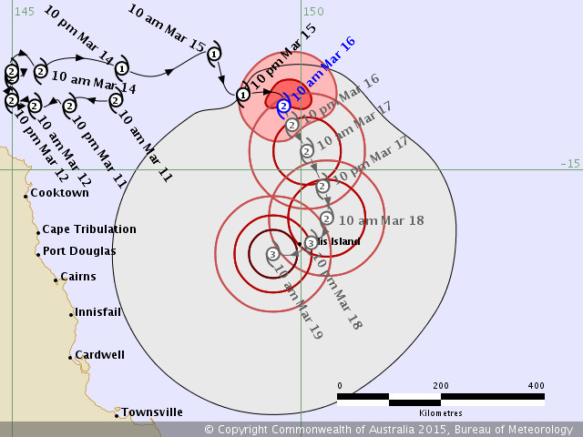
Tropical Cyclone Nathan is expected to return with a vengeance later this week after stopping short of Cape Flattery on the weekend.
------
Tracking Updates: http://www.bom.gov.au/products/IDQ65002.shtml
------
Currently Nathan is still hovering in the Coral Sea, 540 kilometres noth of Cairns and drifting south-southeast at 7 kilometres per hour.
However on Wednesday it is expected to meet a subtropical ridge coming from the south, which will kick the cyclone back west toward the Queensland coast, but further south from where it originally approached.
Bureau of Meteorology Cairns forecaster Andrew Mostyn said it would be difficult to predict exactly where the cyclone would go but said everywhere north of Bowen should be prepared.
"Right now it's too early to say where it's going to hit - that depends on exactly when it turns," Mr Mostyn said.
"But it will definitely come back and when it does it's expected to return as a Category 3."
Mr Mostyn said despite the seeimingly back-to-back sequence of cyclones experienced by the Far North recently, this year's cyclone season was still producing an average number of events.
"We're actually a little bit below average at this stage for cyclone systems," he said.
"Even though everyone is still dealing with cleanup from Marcia and the effect from the first time Nathan came close, we are a little bit behind schedule."


