Tropical Cyclone Ita tracks south along North Queensland coast
Tropical Cyclone Ita tracks south along North Queensland coast
Saturday April 12 2014
UPDATE 10:40am
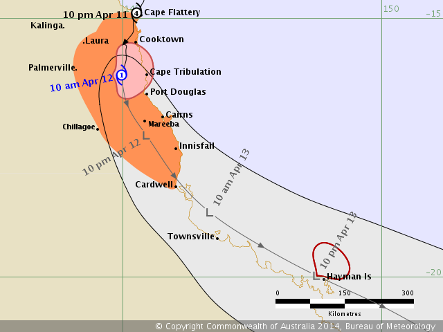
Tropical Cyclone Ita is weakening as it moves southwards overland having crossed the coast north of Cooktown at 10 pm on Friday night. View the latest BOM tracking map
Related stories:
| Are you cyclone prepared? |
| Self evacuations start as Douglas storm surge centre opens |
| <link essential-cyclone-contacts-and-informati.11227.0.html external-link-new-window external link in new>Essential cyclone contacts and information |
| <link port-douglas-marina-evacuated-as-tropica.11231.0.html external-link-new-window external link in new>Bureau of Meteorology forecast tracking map for Tropical Cyclone Ita |
| Supermarkets hit as residents rush for 'cyclone essentials' |
| <link port-douglas-marina-evacuated-as-tropica.11231.0.html external-link-new-window external link in new>Port Douglas marina evacuated as Tropical Cyclone Ita looms |
| <link douglas-residents-prepare-for-tc-ita.11225.0.html external-link-new-window external link in new>Douglas region prepares for TC Ita |
<link cyclone-forces-lizard-island-evacuation.11229.0.html external-link-new-window external link in new>Lizard Island evacuated |
Destructive winds with gusts to 120 kilometres per hour are possible south of Cooktown to Port Douglas for a brief period this morning.
Wind gusts to 100 kilometres per hour are possible in remaining areas between Cape Flattery and Port Douglas and adjacent inland areas possibly extending further south to Cairns and adjacent inland areas including Mareeba later today and as far south as Innisfail, Chillagoe and Cardwell this evening or tonight.
Coastal residents south of Cooktown to Cairns including Port Douglas are warned of a storm tide later this morning. The sea is likely to rise to a level above the normal high tide that may produce minor flooding of low-lying areas.
People living in areas likely to be affected by this flooding should take measures to protect their property as much as possible and be prepared to help their neighbours, and be prepared to follow instructions regarding evacuation of the area if advised to do so by the authorities.
Heavy rain, which may lead to flash flooding, is occurring about parts of the Peninsula and North Tropical Coast and Tablelands districts and should gradually contract southwards with the system over the weekend.
- People in the path of the cyclone south of Cooktown to Cape Tribulation should stay calm and remain in a secure shelter - above the expected water level - while the destructive winds occur.
- Follow the evacuation advice or directions of Police, Emergency Services personnel and local authorities.
People elsewhere between Cape Flattery and Cardwell and adjacent inland areas including Mareeba and Chillagoe should complete preparations quickly and be prepared to shelter in a safe place.
- Boats and outside property should be secured using available daylight hours.
- For emergency assistance call the Queensland State Emergency Service (SES) on 132 500 (for assistance with storm damage, rising flood water, fallen trees on buildings or roof damage).
- Follow the evacuation advice or directions of Police, Emergency Services personnel and local authorities.

